Bathymetric Surveyin Shallow Water
Many bathymetric surveys for projects like shoreline stabilization, engineering design, or infrastructure remediation, require bathymetric surveys to be performed in very shallow waters inaccessible by traditional vessels.
Conducting these surveys in shallow water can be extremely difficult in terms of accessibility, space, fast-flowing currents, submerged debris, navigational hazards, or environmentally sensitive habitats. To mitigate these effects, our surveyors use cutting edge tools like remote-control Unmanned Surface Vessel (USV) technology. This state-of-the-art equipment conducts precise bathymetric surveys in shallow water safely and efficiently.
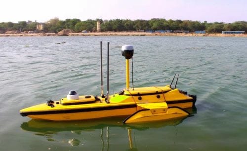
For these shallow water surveys, hydrographic crews use high-tech equipment including Teledyne Z-boats and HyDrone Unmanned Surface Vessels (USV) combined with either a multi-beam or single-beam echosounder, positioned with RTK-GNSS.
For projects such as the survey of bridges and nearshore embankments, topographic mapping is often needed in addition to a bathymetric survey. For this, custom solutions tailored to each project may include the use of small Unmanned Aerial Systems (sUAS) / Drones, mobile lidar, or terrestrial 3D laser scanners.